
Eco & Environment, Poole | Posted on September 30th, 2025 | return to news
Coastal change in Poole Harbour to be tracked and measured
The new Coasts in Mind Mapping Platform will enable communities to identify areas of Poole Harbour that are being lost to the sea.
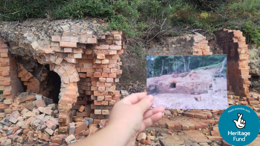
Brick kilns which were in use from the 1600s to 1800s on Brownsea Island — when it was a major local industrial centre — are being lost to the sea.
This has been discovered by the new Coasts in Mind Mapping Platform which has been co-created with local communities from Poole Harbour.
The platform gathers evidence of coastal change by recording residents’ memories, collecting postcards and photos, training people to digitise documents from their local archives, and more — things which aren’t usually part of official climate change conversations.
This innovative community-led approach to addressing the impacts of climate change on coastal areas is made possible with support from The National Lottery Heritage Fund.
Coasts in Mind senior community archaeologist Hazel Crabb said: “The brick kilns on Brownsea’s southern shoreline were first recorded in the 1980s and are a prime example of how archaeological features can be used to monitor coastal change. By collating images and surveys from the past 40 years, thanks to local volunteers and the National Trust, we can track the retreating shoreline, with around four metres of fragile cliff and beach eroded in that time — taking much of the brick kilns with it. The site is almost completely unrecognisable from photographs taken 20 or even 10 years ago.”

Through a programme of free workshops, creative projects, and training opportunities over the next six months, Coasts in Mind is bringing communities around Poole Harbour together to build resilience against future coastal change. Participants can learn to add and moderate contributions to the map, before it is then opened for submissions from the wider community in May 2026.
Project Manager Lawrence Northall said: “Co-designed with community members, the Coasts in Mind Mapping Platform is an exciting and unique new tool, that enables people to curate their own local evidence of climate and coastal change. In doing so, it will give greater value to the expertise of local knowledge and help empower communities to present their own narratives of change in a publicly accessible format.
“Ultimately, we intend this to influence policymakers and wider public perceptions of change, including its causes and effects on local environments, heritage, and front-line communities.”
The Coasts in Mind project will stretch over three years, specifically targeting four key coastal regions: Poole Harbour, Taw-Torridge Estuary in Devon, Swale Estuary in Kent, and Sefton Coast in Merseyside. The aim is for these initial pilot locations to be a model for how this innovative methodology can be used on a national scale, adding a vital piece of the puzzle to addressing the impacts of this globally significant issue.
Explore the Coasts in Mind Mapping Platform at cim.mola.org.uk/map.
Please share post:
LATEST NEWS:

CHARITY OF THE YEAR 2025
Subscribe to the online magazine news letter